


Basics
- Length:
- 28.7 miles (46 km)
- Time:
- Allow 1 hour.
- Fees:
- Only at the special attractions along the way.
Description
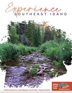
Beginning in gently rolling farmlands, dipping into a tumultuous river confluence, and traveling over the rim of the nation's largest volcanic caldera, Mesa Falls Scenic Byway takes you through some of southeastern Idaho's most compelling scenery. In addition to enjoying breathtaking vistas along the route, devotees of intermountain recreation find countless activities to indulge their passions on the route's 27 miles. Originally a popular path to Yellowstone National Park, the byway offers plenty of reasons to justify a trip in itself.
Your journey begins in the rural town of Ashton. Stop in at one of the restaurants for small-town hospitality and stay the night at a local inn. As you embark on the Mesa Falls Scenic Byway, the first nine miles or so travel through the town's surrounding potato, barley, and wheat fields. The gently rolling terrain stretches for miles in all directions as the Grand Teton Mountain Range looms in the distance.
Soon the fields give way to Targhee National Forest and the route descends into the Three Rivers Canyon. Created by the convergence of Warm River, Robinson Creek, and Henry's Fork, the gorge brims with ponderosa pine, popular fishing spots, and campsites. Continue along the route to climb up to the nation's largest volcanic caldera. Pull over and walk among stands of Douglas fir and aspen. Admire the view of grassy meadows scattered throughout dense pine forests before getting back into the car and following the route to the caldera's floor.
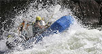
Mesa Falls Scenic Byway travels along Henry's Fork of the Snake River. Under consideration for designation as a wild and scenic river, Henry's Fork offers a variety of recreational activities like fishing, whitewater rafting, and waterfall viewing. Stand nearby and enjoy the cool mist rising from Upper Mesa Falls, the last undisturbed waterfall in the Columbia River System and take a couple of the side trips to other falls in the region. Don't have the gear or expertise to handle the rapids or want an insider's knowledge of the good fishing spots? Check out the listings for local outfitters and guides and create some memories.
Much of the byway lies within the Greater Yellowstone Ecosystem, home to a world-famous variety of charismatic wildlife. As you approach the northern end of the byway, you'll enter Osborne Meadows, a haven for moose, deer and elk. This large meadow attracts the kinds of animals that make Yellowstone famous without pulling in the same kinds of crowds. During wintertime the vast open area attracts snowmobile riders and cross-country skiers as a gateway to the National Park or a destination in itself.
With a multitude of outdoor recreation opportunities, ecosystems and scenic views, Mesa Falls Scenic Byway provides the perfect glimpse of southeast Idaho.
Tourism Resources
Helpful Links
Tourism Resources
Points of Interest
Points of Interest Along The Way
Ashton (ID)
A small town in northeastern Idaho between the Targhee and Caribou National Forests
Directions
Ashton is the byway's southern gateway.
Big Falls Inn (ID)
The Big Falls Inn has served many purposes over the years since it was built by Thomas Elliott. He intended to use it as the headquarters for a power company. Although the power company never materialized, the Inn was put to good use as a stage stop and hotel for the increasing tourist traffic to Yellowstone. Eventually it served as a cafe, saloon, store, dance hall, boy scout mess hall, and Fremont County police officer's clubhouse.
Today the Big Falls Inn serves as the Interpretive Center for the Mesa Falls Scenic Byway and surrounding area. Visit the Center to see exhibits on the geology of the falls and canyon, history of the lodge, the river ecosystem, plants and animals of the area, the Forest ecosystem, cultural history of the area from prehistoric times to present, and maps of other parks and points of interest in the area.
Directions
Near Big Falls
Caribou-Targhee National Forest (ID)
The Caribou-Targhee National Forest occupies over three million acres and stretches across southeastern Idaho, from the Montana, Utah, and Wyoming borders. Activities include mountain biking, hiking, camping, rock climbing, and mountain boarding.
Grand Teton National Park (ID)
The Teton Range, for which the park is named, dominates the landscape with its jagged, glacially-carved peaks that rise without foothills from the west side of the park.
But there's more to the park than the Tetons. There's Jackson Hole, a level valley carpeted with silvery-green sagebrush shrubs that forms the foreground for the mountains. And there are lakes:at the foot of the mountains, thick conifer forests encircle seven sparkling lakes. There's the Snake River: tall cottonwood and spruce trees line the river that bisects the valley into east and west halves. And wildlife: a diverse array of large and small mammals, a few hardy reptiles and amphibians, numerous birds and several kinds of native and introduced fish inhabit the park, along with countless kinds of insects and other invertebrates.
Although the park was originally established to protect the Teton Range and six of the piedmont lakes, the Jackson Hole valley was later included in national park designation. Grand Teton boasts both unusual scenery and large concentrations of wildlife. Grand Teton and the Rockefeller Parkway are adjacent to Yellowstone National Park, and lie at the heart of the Greater Yellowstone Ecosystem, which is the largest nearly intact ecosystem in the temperate part of the world.
Directions
Located east of the byway, in Wyoming
Lower Mesa Falls (ID)
The Lower Mesa Falls is 65 feet high. The overlook here is not as close as the Upper Mesa Falls but it gives a grander view of the falls in relation to the surrounding canyon.
Directions
35 miles north of Rexburg. Off Hwy 47
Upper Mesa Falls (ID)
The falls is one of the most impressive geological sites in Eastern Idaho. The whole Snake River pours over the crest and drops 114 feet to the canyon floor with an explosion of spray. The scenic view is spectacular as you are standing within a few feet of the water going over the falls. Boardwalk and ramps make the falls easily accessible to persons with disabilities.
Directions
35 miles north of Rexburg, Idaho. Off Hwy 47.
Yellowstone National Park (ID)
The osprey soared over Yellowstone Falls, then hovered against the blue sky thousands of feet above the canyon floor. Slowly it descended below the rim, its mottled brown feathers becoming almost invisible against the yellow rocks of the canyon wall.
Viewed from high atop Mt. Washburn, a summer squall rolled slowly down the Grand Canyon of the Yellowstone. To the north, lightning crackled off the Beartooths, as an icy rain pelted the Mt. Washburn lookout into which groups of hikers huddled. Within minutes, the storm passed and the sun burst through the dark clouds.
A pair of Sandhill Cranes strutted in the grasses along the Gibbon River, their red-knobbed heads bobbing up and down. Suddenly they spread their mighty wings and glided smoothly down the river.
You are skiing through frigid air, then suddenly enveloped in steam escaping from deep within the Earth. All around you is a world of white. Waterfalls hang suspended as walls of ice, their ripples tricking the eyes with reflecting light. A geyser unleashes a torrential plume, boiling water crashing into the arctic temperatures.
These are the scenes that entice millions to visit Yellowstone. Straddling the Continental Divide where Wyoming, Idaho, and Montana meet, the park is truly a "Wonderland" for anyone from the casual tourist to the avid outdoorsman.
Directions
Located east of the byway, in Wyoming