


Basics
- Location:
- Between Banks and Horseshoe Bend, a short drive north of Boise.
- Class:
- Class III - IV
- River Length
- 15 miles
- Time:
- Full Day
Description
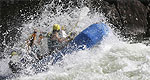
Once the South and North Forks of the Payette join, the best rafting is upstream of the Black Canyon Dam near Emmett. A 15-mile stretch contains some exciting whitewater, perfect for those with intermediate skills. Holes such as Bennett’s Rock and Mixmaster provide challenges of up to Class IV for those who decide to attempt them. Rafters often share this stretch of the river with power boats.
Tour Companies
Riverroots
- Payette and Boise Rivers
- Rafting, Team Building | Youth Programs, Canoeing, Kayaking
- 208-850-7637
Helpful Links
Tour Companies
Riverroots
- Payette and Boise Rivers
- Rafting, Team Building | Youth Programs, Canoeing, Kayaking
- 208-850-7637
River Details
Class:
Class III - IV
River Length
15 miles
Time
Full Day
Guides Available?
Yes