Idaho Map

Request Free Visitor Guides

North Fork Little Timber Creek Trail

Contact Info
Salmon-Challis National Forest
176 North Railroad Street
PO Box 180 Hwy. 28
Leadore, ID 83464

Phone:
208-768-2500
Basics
Length:
2.8 miles
Difficulty:
Intermediate
Time:
1 - 2 hours
Trailhead Elevation:
7400 feet
Elevation Range:
7400 feet to 8450 feet
Elevation Change:
1050 feet

Description

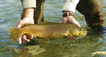
Some fish have been seen in the lake at the trail's end

Good route for those wanting to climb Gunsight Peak

Details

Length:
2.8 miles
Difficulty:
Intermediate
Time:
1 - 2 hours
Trailhead Elevation:
7400
Elevation Range:
7400 feet to 8450
Elevation Change:
1050

Map + Directions


Copyright © 1997 - 2024 The Go Travel Sites. All Rights Reserved and.

Email Page Link

Complete the form below to email this page to a friend or family member's email. You can send yourself an email as well. Your email and your recipient's email will NOT be shared with anyone. See our full Privacy Policy for details.
:
:
:


:
Copy Yourself on the Email Yes No
:
:

1

Select a Free Visitor Guide below

2

Complete the form to receive your guides by mail

Below are the Free Visitor Guides for Salmon. More Visitor Guides are available in Idaho. Click here to view them all!

Visit Idaho Visit Idaho Visit Idaho
IdahoStart planning your Idaho adventure. Vacation is more than just scenery; it’s about making life long memories. Download or order the free Idaho Travel Guide here.
Request this Free Visitor GuideRequested! You're all set! Complete the form below to receive your guides by mail.