


Basics
- Length:
- 33 miles (53 km)
- Time:
- 40 minutes to drive or two hours to see the entire Byway.
- Fees:
- Sam Owen Campground has an entrance fee.
Description
Left in the aftermath of the largest geological event on earth, Lake Pend Oreille's scenic qualities testify of unbelievable power. Witness the effects of the biggest of the ice age floods that shaped the continent during your thirty-three mile drive on Idaho's Pend Oreille Scenic Byway. Enjoy the region's rugged mountain scenery, abundant water recreation opportunities, and laid-back Pacific Northwestern culture. The Byway spends its entire length alongside pristine and scenic bodies of water, inviting you to relax on their beaches or plunge beneath their cool surfaces.
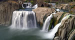
The centerpiece of the Byway is stately Lake Pend Oreille, the fifth deepest lake in the nation. The lake is so deep, in fact, that the U.S. Navy uses it as a submarine base. Pend Oreille's depth isn't its only impressive dimension. An intrepid kayaker needs a week to paddle around its 111 miles of coastline. As you drive the Byway, notice the massive mountain ranges that seem to extend directly from the lake's surface. Glaciers, flooding, and the ancient inland lake, Lake Missoula, carved captivating geographic formations in the area. Bring along your camera and a fresh sense of awe, as you will use both often on your journey.
Your trip down the Byway takes you through a variety of quaint lakeside towns. The largest of these is Sandpoint, the main hub of activity near the Byway. While compact in size, this city packs in outstanding dining and shopping opportunities. As you stroll through the culturally rich downtown area, stop in at its eclectic shops, art galleries, and antique shops for that perfect souvenir. More communities dot the rugged and fertile land along the Byway, including Hope, Trestle Creek, and Clark Fork, the latter of which resides along the river of the same name. Most area towns offer a boat ramp and beaches to get you on the lake or the river as soon and as often as possible.
While the Byway offers easy access to sailing, kayaking, rafting, swimming, and power boating, your choice of activities is hardly limited to water sports. Flanked by water on its west side, Pend Oreille Scenic Byway skirts Kaniksu National Forest on its east side, which is home to its own assortment of attractions. Bring along a mountain bike or some backpacking gear to tromp around the forest's diverse trail systems, or take advantage of quality golfing at one of several local courses. In the winter visit Schweitzer Mountain Resort, the biggest ski and snowboard area around, or seek the area's some pristine mountain terrain for a cross-country skiing trip or a snowmobile ride.
With its breathtaking scenery and recreation opportunities, Pend Oreille Scenic Byway excels both as a pleasant afternoon drive and a destination for several weeks' worth of fun. Whether you spend your trip taking in the galleries and live entertainment, camping in primitive conditions, or just relaxing on the beach or a houseboat, plan on an unforgettable experience.
Tourism Resources
Helpful Links
Tourism Resources
Points of Interest
Points of Interest Along The Way
Cabinet Gorge (ID)
Cabinet Gorge is the historic site of the face of the ice damwhich created Glacial Lake Missoula, a portage site for the nativeKalispel and Flathead Indians, explorer David Thompson, and thesteamboats carrying miners. It is also home to one of the fewprivately constructed hydroelectric projects in the UnitedStates.
Directions
ID
Cabinet Gorge Fish Hatchery (ID)
The Cabinet Gorge Fish Hatchery was designed and built to assistin sustaining the kokanee (landlocked salmon) population of LakePend Oreille. This specialized facility is operated seasonally, butis expanding its use to include the endangered bull trout.
Directions
ID
Clark Fork Driftyards Recreation Area (ID)
The Clark Fork Driftyard Recreation Area is a primitive accesspoint into an expansive river delta, extending two miles acrosschannels and islands. The site offers many opportunities to observewildlife, canoe or kayak, and simply find peace within a naturaldelta setting.
Directions
ID
Clark Fork Recreation Area (ID)
This spot where Clark Fork Recreation Area now lies was acquiredby the Avista Corp. as a component of their dam relicensing toprovide river access for those who want to float the peaceful ClarkFork River. Adjacent primitive camping sites are along the river'sedge in large cedar trees.
Directions
ID
Denton Slough Waterfowl Area (ID)
Denton Slough Waterfowl Area is an elongated shallow slough, forming a bay near the Clark Fork River. This area is a favorite for migrating waterfowl, and is visited each fall by Tundra Swans and each spring by a nesting colony of Western Grebes. This inlet provides habitat to waterfowl, songbirds, and spiny ray fish.
Directions
ID
Hope (ID)
In 1809, David Thompson built the first fur-trading post in the Pacific Northwest near Hope, Idaho.
Directions
On SR 200 about 12 miles east from the junction with U.S. 2/95.
Hope Area Interpretive Site (ID)
This site provides information about David Thompson's exploration of the Pend Oreille area in 1809.
Directions
Hope, ID
Hope Boat and Recreation Area (ID)
A primary public boat launch for recreation upon Lake PendOreille, Hope Boat and Recreation Area is complete with two rampsand docks. Natural gravel swimming beaches are accessible frompaved parking.
Directions
Near Hope, ID.
Hope Community Historical Site (ID)
The Hope Community Historical Site is a small park maintained bythe City of East Hope. A statue commemorating David Thompson's 1809discovery of Lake Pend Oreille is displayed, along with informationregarding the history of Hope and East Hope.
Directions
Hope, ID.
Idaho Panhandle National Forests (ID)
Idaho Panhandle National Forest, Northern Region, ID Predominantly in the Selkirk Mountain Range, the PNF manages over 2.5 million acres. During the spring, summer and fall a variety of activities can be found, including hundreds of hiking trails. There is a great variety of wildlife, fish, clear lakes and rivers and ancient cedar groves. In winter, hundrds of miles of groomed trails beckon nordic skiers and snowmobilers.


