


Basics
- Location:
- East of Pagosa Springs
- Setting:
- Mountainous
- Length:
- 15 miles oneway
- Time:
- 8 to 9 hours
- Trailhead Elevation:
- 7900 feet
- Elevation Change:
- 3000 feet
- Season:
- Summer - Fall
Basic Directions
Go northeast on U.S. Hwy. 160 for approximately 9.5 miles. Turn right on East Fork Road (FDR 667) and travel approximately 4 miles. The trailhead is on the right before the bridge over Sand Creek.
Description
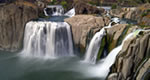
Fifteen miles in length, this trail begins at the Quartz Ridge/Coal Creek Trailhead and returns to East Fork Road further east, near the Silver Falls Guard Station. This steep trail with several switchbacks goes up Sand Creek to Quartz Ridge before dropping down to the East Fork. The last 1.5 miles of trail pass through private property, so please stay on the trail. The highest point is 10,900 feet, the total ascent is 3,000 feet.
Details
Location:
East of Pagosa Springs
Setting:
Mountainous
Length:
15 miles oneway
Time:
8 to 9 hours
Trailhead Elevation:
7900
Elevation Change:
3000
Season:
Summer - Fall


